1. Εισαγωγή
The SingularXYZ L1-Laser IMU GNSS RTK Surveying Equipment is a professional-grade tool designed for high-precision positioning and measurement in various environments. It integrates advanced GNSS technology with a laser rangefinder and IMU tilt compensation, offering centimeter-level accuracy and enhanced efficiency for surveying tasks, even in challenging conditions.

Figure 1.1: The L1-Laser GNSS Receiver in a surveying scenario, highlighting its non-contact laser measurement capability.
2. Βασικά Χαρακτηριστικά
- Professional-Grade RTK Precision: 1408-channel dual-frequency L1/L2 GNSS receiver with 5-second initialization and centimeter-level accuracy. Supports full constellations (GPS, Galileo, GLONASS, BDS, QZSS, SBAS) with anti-multipath technology.
- Hybrid Surveying System: Integrated laser rangefinder for non-contact measurement up to 10m, combined with RTK positioning for inaccessible points.
- Advanced Tilt Compensation: Professional-grade MEMS IMU provides ±60° dynamic tilt operation with auto-calibration, delivering 2cm RTK accuracy for pole-free topographic surveys.
- Long-Range UHF Connectivity: Built-in 2W UHF transceiver supports 15km radio range between rover and base with RTCM v3/CMR correction. Compatible with third-party base stations.
- Field-Optimized Connectivity: 8GB onboard storage, NFC (Touch connection), Bluetooth, USB Type-C, WiFi, TNC Connector, RS232 Serial Port. Web UI for remote configuration and data download. Supports NTRIP/CORS via SingularPad software.
- Military-Grade Field Reliability: IP67-rated magnesium alloy housing withstands -40°C to 65°C operation with water/dust resistance and drop protection.

Εικόνα 2.1: Τέλοςview of the L1-Laser's key features and capabilities.
3. Τι υπάρχει στο κουτί
The L1-Laser IMU GNSS RTK Surveying Equipment package includes the following components:
- L1 GNSS Receiver
- Θήκη μεταφοράς (x1)
- Καλώδιο USB τύπου C (x2)
- Υπερφορτιστής (x2)
- Κεραία μαστιγίου (x1)
- GNSS Adapter (x1)
- Συλλέκτης Δεδομένων SC60 (x1)
- Στήριγμα (x1)
- Λογισμικό SingularPad (x1)
- Οδηγός γρήγορης εκκίνησης (x1)
- Κάρτα γρήγορης εκκίνησης (x1)

Figure 3.1: All components included in the L1-Laser product package.
4. Ρύθμιση
4.1 Αρχική ρύθμιση
Before operating the L1-Laser system, ensure all components are present and charged. Connect the SC60 Data Collector to the L1 GNSS Receiver using the provided bracket and cables. Ensure the whip antenna is securely attached to the L1 receiver for optimal signal reception.
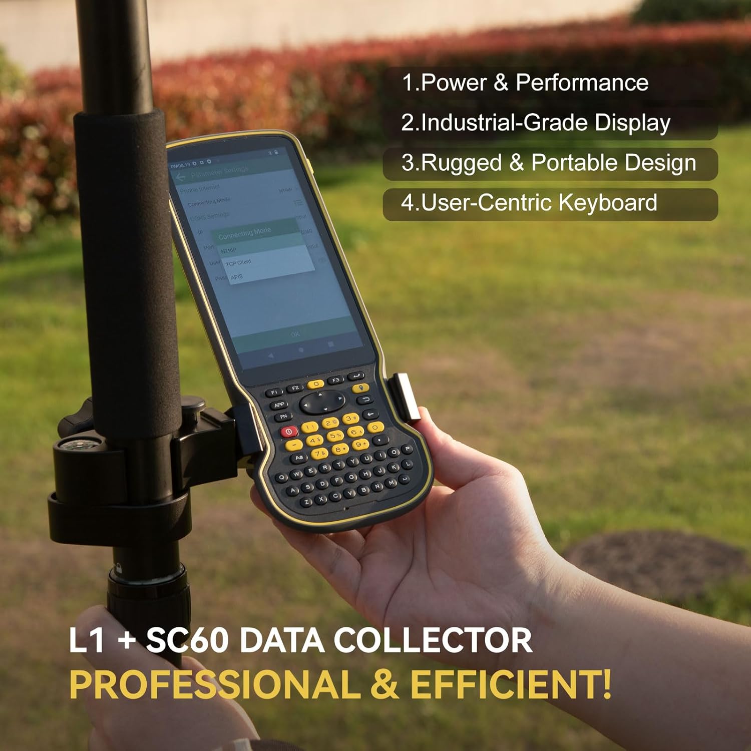
Figure 4.1: Proper assembly of the L1 GNSS Receiver and SC60 Data Collector for field use.
4.2 Flexible Work Modes
The L1-Laser supports various work modes to suit different surveying needs:
- Static Measurement: Record static data using the 8GB onboard storage. Data can be downloaded via the Web Διεπαφή χρήστη
- Internal Radio Base & Rover: Achieve up to 15km range with the built-in UHF radio for real-time kinematic (RTK) corrections.
- Ntrip Mode: Connect through Bluetooth to easily access local CORS (Continuously Operating Reference Station) via PDAs.

Figure 4.2: Visual representation of the three primary work modes.
4.3 Συνεργασία με την Υπηρεσία Διόρθωσης CORS/RTK
To use the CORS/RTK Correction Service, follow these steps:
- Purchase a CORS/RTK Correction Service account in your local area.
- Ensure your PDA device (phone/tablet/data collector) can access the network and supports Bluetooth connection.
- Place your L1 GNSS receiver in an open view του ουρανού.
- Ανοίξτε το λογισμικό SingularPad.
- Click "Communication" and connect to your L1 receiver's SN via Bluetooth.
- Click "Rover" and then "Set Data Link" as Phone Internet. Go to "Connect Mode" and fill in your CORS/RTK Correction Service account details.
- Click "Get" to obtain the Mount-Point list and select the appropriate one. Click Start and Apply.
Σημείωμα: Find the appropriate mount point via the website of your local CORS/RTK Correction Service provider. Ensure the baseline is within 50km.

Figure 4.3: Step-by-step guide for CORS/RTK Correction Service setup.
4.4 Working with L1 Rover + Base
For a Rover + Base setup, you will need two L1 GNSS receivers. Designate one as the base and the other as the rover.
- Connect the L1 base to your PDA. Go to Device > Base.
- For Base Startup Mode, you can input known point coordinates to set up, or select Single Point mode for automatic setup.
- Set Datalink as Internal Radio and customize radio channels, frequency, and protocol according to your needs.
- Save settings and Start Base. The status bar will become Base.
- Disconnect L1 base and connect to the rover in the software.
- Go to Device > Rover, set Data Link as Internal Radio.
- Match and set the same protocol and frequency as the base setting.
- Click Collection to save settings and click Apply.

Figure 4.4: Configuration steps for L1 Rover + Base setup.
5. Οδηγίες λειτουργίας
5.1 RTK Precision and IMU Tilt Compensation
The L1-Laser provides robust RTK positioning. Its integrated IMU allows for tilt compensation up to ±60°, enabling accurate measurements without needing to perfectly level the pole. This significantly increases survey efficiency, especially in challenging terrains or when measuring inaccessible points.

Figure 5.1: Illustration of 60° tilt compensation for pole surveying and visual stakeout.
5.2 Μέτρηση με λέιζερ
The integrated laser rangefinder allows for non-contact measurements up to 10 meters. This feature is particularly useful for surveying points that are difficult or hazardous to access, such as power lines, bridge abutments, or points across obstacles. Simply aim the laser at the target point, and the system will combine the laser measurement with RTK positioning for precise coordinates.
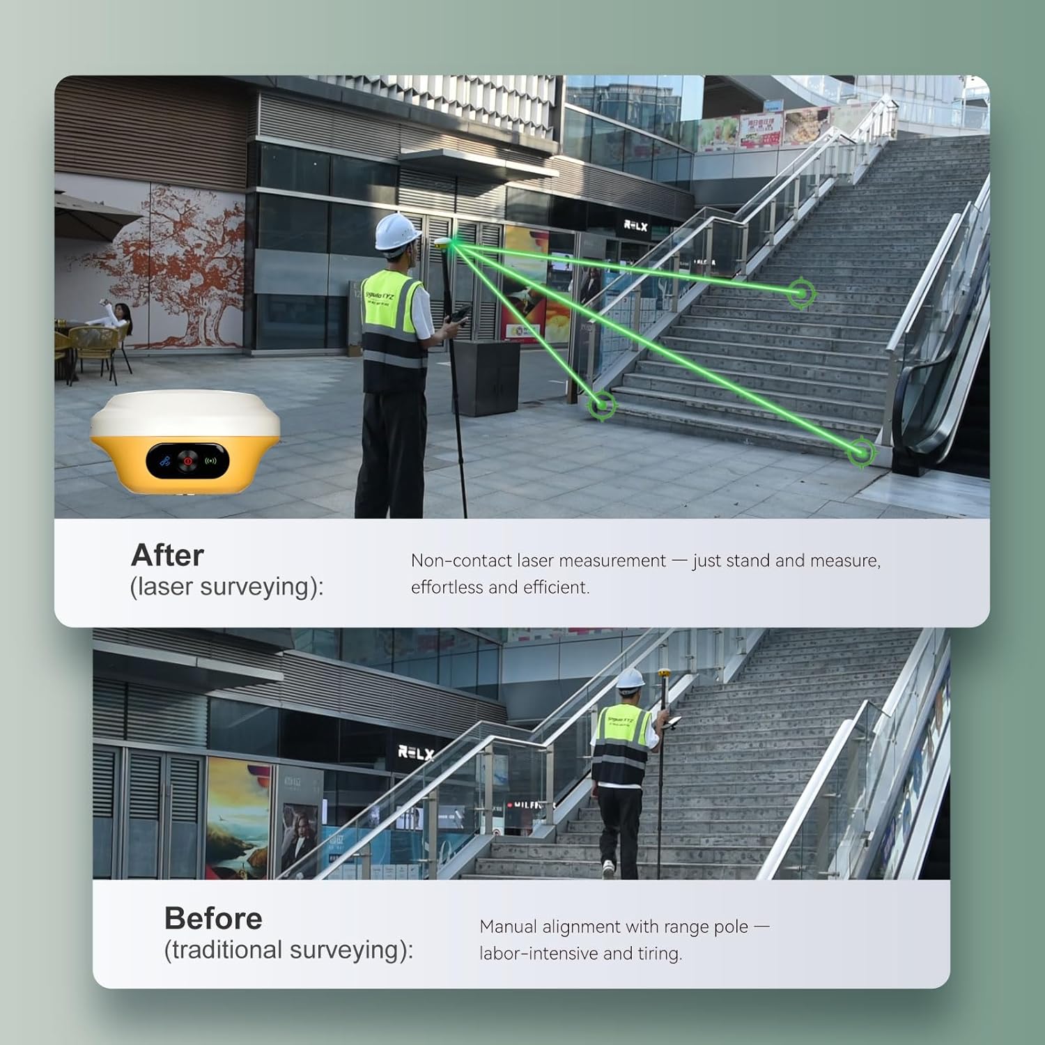
Figure 5.2: Comparison of traditional surveying vs. laser surveying for efficiency.

Εικόνα 5.3: Πρamples of effortless laser surveying in different scenarios.
5.3 Data Collection and Management
The SC60 Data Collector, running SingularPad software, provides a robust interface for data collection. It features a full physical keyboard and a 5.5" 1080P display for efficient data input and viewing. Data can be stored on the L1-Laser's 8GB internal storage and easily downloaded via its Web UI by connecting to the device's Wi-Fi.

Figure 5.4: The SC60 Data Collector, optimized for field data entry.

Figure 5.5: Data download via Web UI and extended battery life.
5.4 ViewΚατάσταση τοποθέτησης RTK
After completing your L1 RTK setup, check the current RTK solution status in the top left corner of the SingularPad software:
- ΣΤΑΘΕΡΟΣ: L1 is receiving RTK corrections stably and obtaining a Fixed RTK solution with centimeter-level accuracy.
- ΦΛΟΤΕΡ: L1 receives corrections from the base/CORS, but due to obstructions or magnetic field interference, the signal reception is not very stable, and the accuracy is sub-meter level.
- ΑΥΤΟΝΟΜΟΣ: Εντοπισμός θέσης δορυφόρου από ένα σημείο χωρίς λήψη δεδομένων διόρθωσης RTK. Η ακρίβεια είναι περίπου στο επίπεδο του μετρητή.
Ακρο: Before surveying, make sure L1 has a clear sky view, free from obstacles like buildings, trees, cars, and more.

Figure 5.6: Understanding RTK positioning status indicators.
6. Συντήρηση
Proper maintenance ensures the longevity and optimal performance of your L1-Laser equipment:
- Καθάρισμα: Regularly wipe down the device with a soft, damp cloth. Avoid abrasive cleaners or solvents. Ensure the laser aperture and GNSS antenna are free from dirt and debris.
- Αποθήκευση: Store the equipment in its transport case in a cool, dry place when not in use. Avoid extreme temperatures and direct sunlight.
- Φροντίδα μπαταρίας: Charge the batteries regularly, even if the device is not in frequent use, to maintain battery health. Avoid fully discharging the batteries for extended periods.
- Ενημερώσεις υλικολογισμικού: Ελέγχετε περιοδικά το SingularXYZ website for firmware updates for both the L1 receiver and the SC60 Data Collector. Keeping the firmware updated ensures access to the latest features and performance improvements.
- Φυσική Επιθεώρηση: Before each use, inspect cables, connectors, and the housing for any signs of wear or damage.
7. Αντιμετώπιση Προβλημάτων
If you encounter issues with your L1-Laser equipment, consider the following common troubleshooting steps:
- Χωρίς ισχύ: Ensure batteries are fully charged. Check all cable connections. Try a different charger or USB-C cable.
- No GNSS Signal: Βεβαιωθείτε ότι η συσκευή έχει καθαρό view of the sky, free from obstructions like tall buildings or dense foliage. Check antenna connection.
- RTK Not Fixing (FLOAT/AUTONOMOUS): Verify base station or CORS connection. Ensure correction data is being received. Check radio/Ntrip settings for correct frequency/mount point. Ensure the baseline distance is within recommended limits.
- Προβλήματα συνδεσιμότητας Bluetooth/Wi-Fi: Restart both the L1 receiver and the data collector. Ensure Bluetooth/Wi-Fi is enabled on both devices. Forget and re-pair Bluetooth connections if necessary.
- Δυσλειτουργία λογισμικού: Restart the SingularPad software. If the issue persists, restart the SC60 Data Collector. Ensure the software is updated to the latest version.
- Inaccurate Laser Measurement: Ensure the laser aperture is clean. Verify the target surface is suitable for laser reflection.
Εάν αυτά τα βήματα δεν επιλύσουν το πρόβλημα, ανατρέξτε στην ενότητα υποστήριξης για περαιτέρω βοήθεια.
8. Προδιαγραφές
| Χαρακτηριστικό | Προσδιορισμός |
|---|---|
| Βάρος αντικειμένου | 1.2 λίρες |
| Διαστάσεις προϊόντος | 4.21 x 4.21 x 2.31 ίντσες |
| Αριθμός μοντέλου είδους | L1-Laser rover |
| Μπαταρίες | Απαιτούνται 3 μπαταρίες 9V (περιλαμβάνονται) |
| Μέγεθος οθόνης | 1 ίντσες |
| Διάρκεια ζωής μπαταρίας | 12 Ώρες |
| Φωνητική εντολή | Buttons, Keyboard, OCR, Touchscreen |
| Ειδικό χαρακτηριστικό | Bluetooth, Touchscreen, Waterproof |
| Τεχνολογία Συνδεσιμότητας | Bluetooth, Ethernet, USB, Wi-Fi |
| Τύπος χάρτη | Παγκόσμιος |
| Λειτουργία εξόδου ήχου | Ψηφιακό |
9. Εγγύηση και υποστήριξη
9.1 Πληροφορίες εγγύησης
The L1-Laser IMU GNSS RTK Surveying Equipment comes with a 1ετής εγγύηση κατασκευαστήΠαρακαλούμε φυλάξτε την απόδειξη αγοράς για τυχόν αξιώσεις εγγύησης.
9.2 Τεχνική Υποστήριξη
SingularXYZ is committed to providing reliable support for its products. If you require technical assistance or have questions regarding the equipment's operation, please:
- Refer to the manual included in the package.
- Email the SingularXYZ technical support team for assistance.
- Visit the official SingularXYZ website to get in touch with support.
- Video conference guidance for RTK GNSS survey equipment is also available to assist you.


